Lecture: the Archaeology of Roxbury by Jason Turgeon

Like Roxbury History?  Then you’ll need to be there for this on Monday, 10/29, 6PM at the Haley House:

Explore the archaeology of Roxbury with City Archaeologist, Joe Bagley. Lecture covers the 7,500 year history of the place we now call Roxbury including Revolutionary War sites, Native American habitation, and the industrial sites of the neighborhood.

Who is Jeep Jones? by Jason Turgeon

Summer is a busy time for me, so I’ve taken the last couple of months off from the blog. Unfortunately, summer is nearing its end next week, so it’s time to dust off the books and start clearing out the backlog of great history that I’ve been accumulating since June.

First up is this bio of Clarence “Jeep” Jones, namesake of the park next to the Timilty Middle School.  On August 22nd, there was the unveiling of a new sculpture, along with plenty of accolades for Jones, at the park titled “The Value of a Life," (video link) intended to bring some hope to our city’s neverending problem of youth violence.  And coming up on October 18, Mr. Jones will be one of three Roxbury residents honored with a Puddingstone Award at the Heart of the Hub, Discover Roxbury’s annual fundraiser.

The Value of a Life

With all of these accolades, I thought it would be interesting to find out a bit more about Mr. Jones.  Getting a complete picture of him has proven to be more of a challenge than I anticipated.  There are a few tidbits online, but nothing of sufficient depth to satisfy my curiosity about a man who has a park named after him and who commands the respect of every city official in Boston.  

There are a few different sources of info online for Jones.  One is his official bio at the Boston Redevelopment Authority, where he serves as the Chairman of the Board.  Another is this Bay State Banner article about street basketball players of the 1950’s.  Mr. Jones was apparently quite the hoops star, and his skills undoubtedly led to his acceptance at Winston-Salem State University, where he graduated in 1955.  His basketball prowess was sufficient to get him elected to the WSSU basketball hall of fame earlier this summer, according to this article in the Winston-Salem Journal.  

After a bit more searching, a colleague of mine emailed an unsourced bio that she suspects was informed by Mr. Jones or his wife.  The picture of his life is now much clearer, but not complete.  Here’s what I’ve been able to figure out.

Mr. Jones was born in Roxbury, probably about 1933.  He attended Boston Public Schools and graduated from Brandeis Vocational HS.  He was a an all-around athlete who ran track and played football, but it’s clear that his best sport was basketball.  After high school, he attended WSSU and was a 4-year letterman under legendary coach Clarence “Big House” Gaines while earning his BS in education.  His time on the court introduced him to other up-and-comers including Gene Walcott (later knows as Louis Farrakhan) and future mayor Ray Flynn.  Following college, he served 2 years in the US Army.  He also has a Master’s in an unknown subject from Goddard College in Plainsfield, VT.  

Once he’d finished his education, he returned to Roxbury.  He taught at the Dearborn School during the day and as a gym instructor at the Norfolk House by night.  As an aside, this is the first time I’ve heard of the Norfolk House having a gym or gym instructors.  He then moved on to a position as a youth worker for the city and was promoted to a supervisory position.  In 1965, he became a youth probation officer and later worked for the mayor as coordinator of youth activities. More promotions followed, including a stint as head of the office of human rights, but always stayed involved with Roxbury youth and basketball coaching. 

Jeep Jones

Mr. Jones has had many notable firsts as a city employee, including being the first minority youth worker, black juvenile probation officer, black deputy mayor, and black chairman of the BRA.  He’s been on the board of the BRA since 1981 and has been the chairman since 1989.  Among his many honors, he was awarded an honorary doctorate in public service from Northeastern University in 2005 and received a “Living Legend” award from the Renaissance School earlier this year.

If you have more pertinent details to offer about Clarence “Jeep” Jones, including his birthday or the reason he’s called “Jeep,” please let me know via email or leave the info in the comments. 

The Everett Letters by Jason Turgeon

This little Fort Hill History blog is only one of several blogs that covers history in the area.  Another great resource for history buffs is South End History, a blog run by Hope Shannon of the South End Historical Society.  

Recently, the SEHS received a set of letters known as the Everett Letters from Richard Card, the founding president of the organization.  As they’re described at the SEH blog,

the letters were written between 1851 and 1859 and contain the correspondence between Otis and Elizabeth Blake Everett in Boston and their son Otis Blake Everett who was working in India.  Otis and Elizabeth Everett lived in a house near where the Cathedral of the Holy Cross stands today….They contain an immense amount of detail about family connections, weather events, weddings, births, deaths, recreational activities, business concerns, trade items, and so much more.

Hope hasn’t posted all of them yet, but she does have the first three trancribed and on the blog.  These letters, from August 19, September 23, and October 14, 1851, offer tantalizing glimpses into our own neighborhood’s history.  Even where Roxbury isn’t officially called out, the ties between the cities are plain thanks to the frequent mentions of names like Weld, Clapp, Flagg, and Fisher.  

I won’t try to recap all of the letters here, but of particular interest is Thomas Everett, son of Otis Everett and brother of Otis Blake Everett, who was the recipient of these first three letters.  Thomas married in 1854 and moved to Roxbury with his new wife Sarah (Greene).  The 1866 Roxbury Directory lists him as boarding in a house at the corner of Highland and Cedar, an intersection I walk by daily:

Another fascinating tidbit is the mention in both the August and September letters that their neighbor Jacob Flagg, a grocer, had sold his store and bought out Horace King’s omnibus line.  I wrote about King’s transit line from Norfolk House back in December.  Unfortunately for all concerned, Flagg wasn’t much good at the omnibus business and King had to come out of retirement a few years later to take control, but by then the horse railway was established and the omnibus business was never really the same.  Still, it’s fascinating to read letters written by the neighbors of these businessmen, and it’s almost certain that Thomas Everett and his family rode the omnibus from their home on Highland to his parent’s house on Washington Street fairly regularly.

Also worth noting is the recount of the tornado sometime between the August and September letters.  The tornado damaged buildings in Cambridge and Medford, as well as ripping the roof off of Mr. Pierpont’s house in Roxbury.  Roxbury historians will remember the Pierpont name from “Pierpont Village,” the name of the old mill and surrounding buildings that once occupied the area where Roxbury Crossing is now, as well as “Pierpont Castle,” the magnificent mansion now replaced by the Basilica on Mission Hill.  It’s not clear which house had its roof ripped off, but judging by the dates I would guess that it was the Pierpont Castle.  Sadly, it appears that several people were killed in the disaster.

Yet another noteworthy item comes at the bottom of the September letter.  Otis Everett makes a casual note that he has

not seen either Mr. Sharp or Bradlee since they stopped payment [in other words, their business failed]  I learn that Mr. Bradlee & Mr. Hale pay all their debts.  You know that I have always said that young people living so fast would sooner or later come to the end of their purse.  Mr. Jonah B. felt rather cross about it.  I have no more news & so can only wish you a pleasant voyage home. 

It’s pure conjecture on my part to wonder if this is a reference to some members of the Hale and Bradlee families that were so prominent in Roxbury about this time, but it does seem likely.  

Roxbury Explored, 1888 by Jason Turgeon

Back in April, Mark posted about “Grab Village,” a completely forgotten district of Roxbury and Boston that extended on both sides of Tremont street around Ruggles, in the no man’s land where the southwest corridor, BPD headquarters, and the future site of Tremont Crossing.  He’d heard of Grab Village, but had to do some serious sleuthing to find out where it had been.

His search led him to the Sunday, September 23, 1888, edition of the Boston Daily Globe and a lengthy article titled “Roxbury Explored.”  The article dives into all sorts of great tidbits about Roxbury during its heyday 125 years ago, including descriptions of the stores at Dudley, the crowds in Grab Village, the Roxbury peach crop, the animosity of Roxbury youths towards Boston “chucks,” the parting stone at Eliot Square, and much more.

It took me a while to locate a PDF of the page in question, but I’ve found it and am hosting it online here.  Take a look for yourself, and think about Grab Village next time you drive down Tremont Street.

The Great Heat Wave of 1911 by Jason Turgeon

It’s going to be hot in Boston the next few days, with temperatures bumping up against 100 tomorrow.  That’s the kind of heat that can make life unbearable if you’re outside.  But no matter how bad it gets, it’s going to be nothing like the great heat wave of July 3-7, 1911, that killed hundreds of people from Chicago to the east coast.  The hottest day was on July 4th, at 104 degrees in Boston, still the hottest day ever on record in the city.  At Roxbury’s annual 4th of July parade many people passed out in the heat.

In a time before air conditioning or fans, men in their 30s dropped dead after a days’ work in the factory, infants died in their cribs, horses dropped on the street, and 5000 people were reported to be sleeping on the Boston Common overnight to try to escape the heat.  The heat was so intense that it drove people in every major city to suicide, including Jacob Seegar of Roxbury.

I have to imagine that if 5000 people were crowded onto the relatively low-lying common, many people would have been sleeping in Highland Park where there would have been the best chance of finding a cool breeze.  And I’m sure that the brewery ice houses were working overtime to do their part, although dozens of factories took the rare step of shutting down operations during the heat wave.  But ice and a spot to sleep on the grass don’t hold a candle to modern fans, swimming pools, and air conditioning…to say nothing of modern fashions that let us wear shorts and t-shirts!  

by Jason Turgeon

cityofbostonarchives:

M. Gertrude Godvin School - Walnut Ave., Roxbury, Boston, MA. School building photographs circa 1920-1960   (Collection # 0403.002)
   This work is free of known copyright restrictions.  Please attribute to City of Boston Arch…

cityofbostonarchives:

M. Gertrude Godvin School - Walnut Ave., Roxbury, Boston, MA. School building photographs circa 1920-1960   (Collection # 0403.002)

Public Domain Mark
This work is free of known copyright restrictions.  Please attribute to City of Boston Archives. For more photos from this collection, click here

by Jason Turgeon

Love the awesome Roessle sign in this City of Boston Archives photo.
cityofbostonarchives:

790 Albany St., rear from Southampton Street, South End, 28 May 1915, ca. 1914-1918, Special Examination photograph collection, 1914-1918 (Collection # 5410.…

Love the awesome Roessle sign in this City of Boston Archives photo.

cityofbostonarchives:

790 Albany St., rear from Southampton Street, South End, 28 May 1915, ca. 1914-1918, Special Examination photograph collection, 1914-1918 (Collection # 5410.010), City of Boston Archives

Public Domain Mark
This work is free of known copyright restrictions.  Please attribute to City of Boston Archives. To see more images from this collection, click here

by Jason Turgeon

I’m reblogging this great pic of the David Dudley House.  It’s been on my list to write about this for a while now, but I can’t seem to get the whole story on who David Dudley was or what is planned for the house.  If you have any …

I’m reblogging this great pic of the David Dudley House.  It’s been on my list to write about this for a while now, but I can’t seem to get the whole story on who David Dudley was or what is planned for the house.  If you have any info on it, please share!

Launch Party 6/16 for The Rising at Roxbury Crossing by Jason Turgeon

James Redfearn, an author born and bred in Mission Hill who also happens to be an ex-cop and a photographer, has written a new book about Boston in 1919, including the police strike that paved the way for public sector unions.  It is largely set in the Roxbury Crossing police station that used to stand not too far from the present day T stop.  From the book’s website, it looks like most of the action takes place in Mission Hill, but hopefully there will be some references to Fort Hill, too.

There’s a launch party for the book tomorrow from 5-8 at the Mission Bar and Grill at Brigham Circle.  It’s $10 to get in, proceeds to charity.  Details here.

Here’s a blurb from the website about the plot:

“The Rising at Roxbury Crossing” by James Redfearn follows a local rookie cop caught up in the Boston Police strike and the Irish war for independence in the tumultuous year of 1919.

“It’s a fascinating period in Boston history,” Redfearn said in a Gazette interview last week. “History carries the story.”

A retired State Police trooper, Redfearn grew up in the Mission Main public housing development, then known simply as the Mission Hill project, in 1947 to 1962. His undergrad degree in political science included a minor in history, and he holds a graduate degree in writing from Harvard.

The hero of his debut novel, Willie Dwyer, is also a local. The fictional police rookie is assigned to the real-life Station 10 in Roxbury Crossing, which once stood on Tremont Street just past Terrace Street.

“Willie lives in a rooming house on Iroquois Street. Mission Church has a small role in [the novel], too,” Redfearn said.

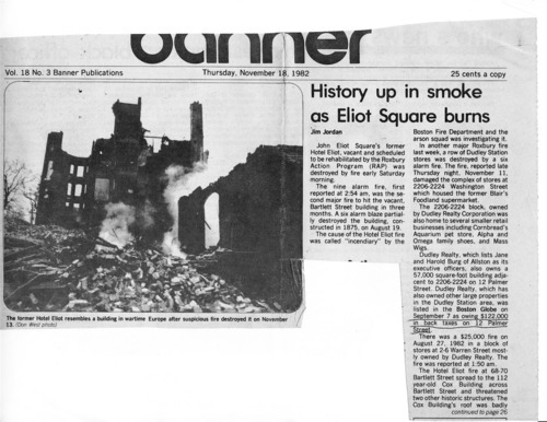
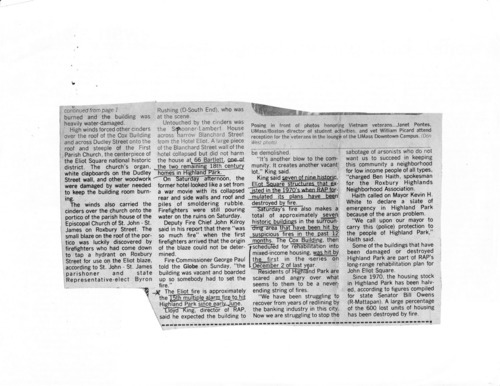
More on the Hotel Eliot fire by Jason Turgeon

Yesterday’s storm forced us to postpone FIGMENT until July 28-29, so I don’t get to relax and go back to history blogging just yet.  But Richard Heath shared the following news clip about the massive fire that destroyed the building and almost took the Cox building and First Church along.

I’ve been meaning to spend some serious time at the library researching the arsons of the late 70s and early 80s.  If anyone reading this has any info on the fires or any similar news clippings, photos, etc., please pass it along in the comments, suggestions, or by emailing me: jason DOT turgeon AT gmail DOT com

Click each picture to download a higher-res file that’s easier to read.

The Hotel Eliot by Jason Turgeon

I haven’t been posting much recently, mostly because I also run a little art event called FIGMENT Boston that takes up most of my free time in the spring.  This year it will be June 2 and 3 on the Rose Kennedy Greenway downtown, so please come pay a visit to see what’s been keeping me busy.

Those of you familiar with Eliot Square will know about the large vacant lot on the corner of Bartlett and Dudley next to the Norfolk House and across Dudley Street from the First Church and the Cox Building.  You can see the distinctive bow front of the Cox building on the right in the aerial shot below. Norfolk House is the building on the left.

I’ve often walked by that spot and thought how wonderful it would be to have another building there, perhaps a place with a restaurant on the ground floor to lend some life to Eliot Square.  But it wasn’t until recently that I discovered that there was a magnificent hotel there for over 100 years - the Hotel Eliot.

Hotel Eliot

The hotel, built in 1875, was one of the first apartment houses in Roxbury.  Unlike today’s hotels, which connote a short term stay, hotels like this one 130 years ago were a new concept in housing, in which multiple families would live in the same building.  There were also hotels for more transient visits, which probably caused some level of confusion. 

The Hotel Eliot was built at the beginning of Roxbury’s major period of densification from 1870-1900. In the 50 years before it was built, Fort Hill had gone from being a rural farming community to a pleasant suburb for the upper middle class, full of country estates which were gradually parceled off into single family home lots.  But as the population of the area grew thanks to immigration and wealth grew along with industrialization, the need for multifamily housing presented itself.

At first, this took the form of the rowhouses we all know and love.  This was multifamily housing, but with shared walls only, not shared ceilings and floors.  The Hotel Eliot, and its 1871 predecessor on Warren Street, the Hotel Dartmouth, were the first real apartment houses in Roxbury.  Before long, apartment buildings in Boston evolved into the triple deckers that were built in such great numbers from the 1880s through the early 1900s.  Although the triple deckers offered more outdoor space, cost less for developers to build, and probably had other benefits besides, I think it’s fair to say they have nothing on the Hotel Eliot in terms of beauty.

It pains me to think that such a magnificent building once graced Eliot Square, and that it escaped saving.  Hopefully when that vacant lot is eventually redeveloped whoever is in charge of the architecture will find a way to bring back some semblance of its style.  And who knows, maybe we’ll finally get a restaurant in Eliot Square?

There’s not much info about the Hotel Eliot on the web, although I hope to be able to dig some up in future visits to the various historical societies around town.  The Right Here in Roxbury wiki says that the hotel survived until November of 1982, but I haven’t been able to turn up any info to corroborate that from my searches of the Globe’s online archives. Given the time period, it’s a safe bet that the hotel was a victim of arson, but if anyone has any more info about the building’s last years please pass it on!

Everything you ever wanted to know about Joseph Warren by Jason Turgeon

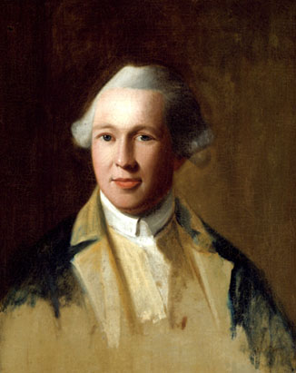
Dr. Joseph Warren is one of Roxbury’s most enduring historical figures.  Before his death at the Battle of Bunker Hill, he was a leading citizen in colonial America, and a leading member of the movement for our liberty.  He’s best remembered both for his role at Bunker Hill and for being the person who sent Paul Revere and William Dawes on their midnight rides.

His family farm, which included many acres of the orchards Roxbury is remembered for, wasn’t in Fort Hill itself but quite probably bounded the hill along what is now Washington Street.  The family home was very near what is now the Boston Evening Academy behind the corner of Warren and Winthrop, just a few yards from the Yawkey Club and the Dudley Library.  Dr. Warren and his family would have come to Eliot Square at least weekly for their Sunday visit to the First Church.  He also attended Roxbury Latin, then situated somewhere in or near Eliot Square (I haven’t quite located the exact spot yet) and also taught there for a year after graduation.

I won’t delve too much more into his life, though, because Dr. Sam Forman has not only written a biography of Joseph Warren but also, in a true act of kindness and sharing for all future historians, is publishing his entire collection of research into Warren’s life online over the next couple of years at the website http://www.drjosephwarren.com/.  I share his frustrations at the difficulty of finding historical materials and I’m overjoyed that he’s elected to make this gift to the world freely available.

So head on over to the site and check it out.  He’s adding new material weekly and will continue to do so for quite some time.  Right now, you can read a transcription of Dr. Warren’s purchase agreement for a slave he bought from Joseph Green for 30 pounds and an additional 10 pounds of pottery, provided he felt “the negro worth the money.”  You can also read the full text of the speech he gave at the state house on the second anniversary of the Boston Massacre, and many other of his speeches and writings.  And be sure to take a look at the variety of portraits Dr. Forman has collected before you leave.

Three great posts on early rail in Roxbury via And This is Good Old Boston by Jason Turgeon

And This is Good Old Boston, one of three Boston history blogs by Mark Bulger (along with great blogs about JP and the Stony Brook), has published three posts recently that all touch on various aspects of transit in our part of Roxbury.

March 5 saw a post that reprinted a Boston Globe article from 1928 that featured an interview with RHJ Nagle, the very first man ever to be fitted for a uniform as a streetcar conductor in Boston.  His route?  The Metropolitan Streetcar line from Bartlett Street, then as now a transit depot, to the ferry dock in East Boston.

Mr Nagle had the distinction, when he was a conductor for the old Metropolitan St. Railway, to be fitted with the first uniform ever worn by a street car conductor in Boston.

His run was from Bartlett st, Roxbury, to the East Boston ferry. It was the Highland car lines, and the cars were painted in plaids and named after popular heroes and heroins, including Flora MacDonald and Grace Darling. Fares were six rides for a quarter, half fares were three cents, single fares were a nickel. The hours were from 8:45 a m to 12:00 midnight and the pay was $1.75 a day. he had a layoff of four hours in the afternoon.

A couple of weeks later, on March 26, there’s a post of an 1887 Boston Globe article detailing the evolution of Boston transit up to the then-modern “comfortable horse cars,” which themselves would be eclipsed in just a decade by electric cars.

The article describes many of the early transit innovators of Boston, including Horace King.  I wrote about King back in December in my post about early Roxbury public transit, and this article fills in several missing details.  Here’s a sample of what you’ll find:

Horace King, in whom the Roxbury line became finally vested, was an enterprising man. He is still alive today, or was recently, resting from a busy life upon the resources gained from his skill in manoevering this line of omnibuses. About 1850 Mr King made a radical change in the system, but supplanting the “arks” was the four-horse omnibuses were called in disparagement, with two-horse coaches of the New York pattern. The bell boys departed likewise, much to the pleasure of the patrons, for they were a saucy and overbearing set.

Finally, on April 16, Mark wrote about the Daniel Nason, a wood-fired locomotive built at the Roxbury Locomotive shop along the Boston and Providence train line that ran through the Stony Brook Valley.  The locomotive shop wasn’t in Fort Hill, but it was very close at the approximate location of the Ruggles T station and the new Northeastern dorms.  Given the location, it’s likely that the builders spent a lot of time in Roxbury Crossing, Roxbury Street, and Dudley Square to do their shopping and dining.

Exploring the 1940 Census by Jason Turgeon

Last week, the National Archives released the full documents from the 1940 Census, which started on April 1 of that year.  There’s a federally mandated 72-year waiting period from the time of a census until the full data, including such info as names, occupations, ages, marital status, and income, can be released.  

On April 6, 1940, census enumerator William M. McMorrow stopped by my house on Beech Glen Street and interviewed Daniel Fallon, the 60-year-old widower who lived here, in my 2-bedroom home, with his son and 4 daughters, all between the ages of 15 and 27.  In Mr. McMorrow’s careful handwriting, we can learn a lot about life at the tail end of the Great Depression for Danny Fallon and his family.  

Mr. Fallon, unlike some of his other Irish neighbors on Beech Glen St., was a native-born American.  He had nothing but a 4th grade education, although he made sure that all of his children finished high school.  A victim of the great depression, he hadn’t “worked” in 10 years, but thanks to the “emergency work” programs of FDR (which were counted differently than regular employment), he managed to make $1025 a year as a laborer constructing sewers.

His eldest daughter Geraldine, still single at the old age of 27, pulled in $1000 a year as a hospital stenographer, and her younger sister Margaret had worked 33 hours the previous week as a sewing instructor in Boston Public Schools.  The work obviously wasn’t steady, as she’d only managed to bring in $383 the previous year.  Daniel Jr., 21 years old and unemployed for the last 21 weeks, had last worked as a  shipper in an office supply company, where he’d made $504.  His two younger sisters, Veronica, 19, and Catherine, 15, were listed as students.  All told, the family of 6 was surviving on less than $3000 a year, 1/3 of that from government make-work programs, but at least they owned their own home, valued then at $2200.

In the 1940 census, the 14th and 29th person interviewed on every page (out of 40 people, or 5% of the total), were randomly selected for a few more questions.  Daniel Jr. was one of those 5%.  We learn that both of his parents, including his deceased mother, were born in Massachusetts.  We also can make out that although Daniel Jr. was not a veteran (although there’s a good chance he ended up fighting in a couple of years), his father Daniel Sr. was. We learn that they spoke English in the home when he was a child.  And most interestingly, we learn that he was one of the first citizens to get one of those newfangled Social Security Numbers.

Their neighbors were in similar situations.  By 1940, the majority of people in the neighborhood were native-born, but the recently-ended immigration boom still showed.  The neighborhood in 1940 was more heavily Irish than it had been 30 years earlier when it was sometimes called “German Hill,” but there were also Italians, Poles, and many others.  Next door, Thomas and Olga Constantine, the Albanian immigrants with 3 young native born sons, rented out one of the units in their triple decker to Greek-born Constantine Tjaerlis, along with his Turkish wife and their two grown sons, born in Massachusetts.  It must have been an endless source of confusion, Constantine the landlord and Constantine the tenant.  I’m sure there was no shortage of jokes from the Irish neighbors.


The National Archives site hosts all of the many thousands of documents from the 1940 census for free, but it’s a bit hard to navigate.  The basic process to look up an address is to find your enumeration district, which is a smallish block of territory.  My enumeration district, 15-394, covers Fort Ave, Beech Glen St, Highland from Fort to Marcella, and Thwing Street.  

You can find your enumeration district on the NARA website, but I’ve gone to the trouble of finding the page of the maps that has the enumeration districts for Fort Hill already.  Download the full .jpg image from my mirror here (right-click and select “save as”).  From there, rather than using the NARA (National Archives) website, it’s easier to use this handy site set up by historian Steve Morse as a public service.  Just enter your ED number and click “NARA viewer.”

If the map doesn’t work for you, Mr. Morse also has an ED finder that’s superior to the one on the NARA website.  Enter as much info about the address as you can and it will guide you to the right ED.  Again, just click “NARA viewer.”

Once you’re at the NARA viewer, things are still a little confusing.  The National Archives site is a bit slow and not particularly well-laid out.  If you know that you have the right ED number selected, you can download the images and view them in a photo viewer (I like the free IrfanView for this kind of work, but you can use whatever viewer you like).  You can choose to download a single page or all of the pages for the district, in standard or high resolution.  The high resolution pages form a pretty big .zip file, so don’t do this on dial-up.  

You’ll probably have the best success just downloading all of the pages at once as a high-resolution file and searching them in your photo viewer instead of trying to use the viewer on the NARA website.  Street names are written on the far-left, in vertical handwriting.  House numbers on the street are in the first column to the right, then another number that indicates the order in which the families were interviewed.  It takes a little while to figure it out, but once you do it’s pretty self-explanatory.

Have fun!  If you find anything amazing, post it in the comments!

Patriots Day is coming up - celebrate on Fort Hill! by Jason Turgeon

For those of you lucky to be home on Monday, April 16, you can celebrate the midnight ride of William Dawes and the battles of Lexington and Concord right here on Fort Hill.

Here are all the details, courtesy of Discover Roxbury:

Patriot’s Day is continued to be observed annually.  Join the Roxbury Collaborative in celebrating Boston’s role in freeing the American colonies from British Occupation.  On the third Monday of April, begin your day with a buffet breakfast at the UU Urban Ministry/First Church in Roxbury at 8am.  Historic speeches will follow and at 10am., you will be able to witness a re-enactment of William Dawes’ horseback ride from Roxbury to Lexington and Concord. 

The William I Brown Memorial Scholarship will be presented to high school students who have demonstrated civic engagement in the community, and a local resident will receive an Unsung Hero Award. The day’s events end with a free one hour trolley tour of Roxbury. Those not wishing to take the tour can instead enjoy open house visits to the Dillaway-Thomas House, the Shirley-Eustis House, and Eliot Burial Ground.

Dr. Adam Stewart, Seraphine-Maker, and 48 Centre St by Jason Turgeon

Fort Hill resident Colin T. told me about a story a friend of his had come across in a back issue of the quarterly magazine of the Reed Organ Society.  Reed organs, also known as pump organs, were small organs commonly found in the 19th century in better homes and small churches that couldn’t afford full pipe organs.  This story was about a seraphine made by Adam Stewart of Roxbury.  Seraphines were early versions of reed organs.

The story is an amazingly well-researched history of an unusual seraphine that the authors found in Portsmouth, NH.  The organ had a plate that identified it as made by Adam Stewart of Roxbury in December, 1838.  The authors were able to track down Mr. Stewart’s entire history from his birth in Scotland in 1776, to his immigration to Baltimore in 1810, to his leaving his first wife and children and heading to Boston, where he fell in love with a woman he could not marry and had many more children with her.  It must have been quite scandalous at the time.

Dr. Stewart was a machinist, piano-maker, inventor, and something of a physician, hence his title.  He was apparently successful in at least one of his trades, as he was able to build the mansion that still stands at 48 Centre Street, along with a barn and outbuildings.  After his death in 1842, his illegitimate family stayed on in the property until 1860.  You can see the house and outbuildings listed as belonging to his son Edward on the 1852 map, and then see that it had been sold and the land subdivided by 1873.


I contacted the Reed Organ Society and they’ve graciously provided a PDF of the entire story of the seraphine, Dr. Stewart, and a bit of Fort Hill history.  It’s a great story worth reading, and it contains plenty of hard-to-find details about the good doctor and his family that must have taken absolutely forever to put together, so head over to this link and download the PDF.

After you visit that link, you can read more about the house itself on a website put together by current owners Ed and Lisa, who did a marvelous job restoring it before moving to their current house on Highland St.  I was lucky enough to get a tour of the house from some friends of mine who briefly lived there, and I can say that it’s both a magnificent property and that Dr. Stewart must have been quite wealthy to live in such a place.  There are some differences about the original owners and builders in Ed and Lisa’s version, but both stories put the house at about 1835 and have Adam Stewart as the eventual owner by the time of his death in 1842.  

Legend has it that Aerosmith used the large upstairs room as a practice space in the 1970s, continuing its musical heritage.  

Thanks to Colin for the tip and a very big thanks to the board at the Reed Organ Society for allowing me to repost their PDF.

Walking the Boston Post Road by Jason Turgeon

Mile Marker 3

Most of us know about the parting stone in Eliot Square and the mile marker just a few hundred yards south on Centre Street that tells us we are 3 miles from Boston.  But did you know that Centre Street, aka the Road to Dedham, was once a part of the Boston Post Road that led to Providence and New York?

If you don’t know the story of the Post Road, or even if you think you do, you should head on over to JP resident Gary Denton’s marvelous blog Walking the Post Road.  A couple of years ago, Mr. Denton walked the entire Post Road, all 283 miles of it, starting at the State House in downtown Boston and ending up in Manhattan.  He did the trip in stages and wrote down his findings in 65 lovingly researched blog posts.

Fortunately for us on Fort Hill, his early posts are among the most detailed.  You might not have time to read all 65 posts (although I bet you’ll find it hard to stop once you start), so if you want to stick to the Roxbury/Fort Hill history, you can read only entry 5 (Roxbury Gate to the Parting Stone), entry 6 (mile marker 3 and Paul Dudley), entry 7 (Centre Street and the Roxbury Russet), and entry 8 (the Stony Brook, Hoggs Bridge, and Jackson Square to Hyde Square).  But you should really start at the beginning.

And for those of you who want just the facts (and if so, what are you doing reading a neighborhood history blog?) here they are:  ”The” Boston Post Road was actually one of several routes used by postal services over the years to connect New York and Boston, but the route that goes through our neighborhood is the oldest.  The mile markers were built around 1729-1735 by Paul Dudley, the 3rd notable Dudley in Roxbury.  They were there to assist travelers through what was then sparsely populated farmland and wilderness.  The mile markers denote the distance to the old State House in downtown Boston at the corner of State and Washington, and the route starting at the State House takes you south on Washington to Dudley Square, then up Roxbury Street to the Parting Stone, then south on Centre Street through Fort Hill and JP.

But the facts alone are boring.  Do yourself a favor and head over to Walking the Post Road to read the details.

If I ever catch the tagger who did this I’m going to indelibly mark his colon with his Steel Blitz marker.

Roxbury During the Siege of Boston by Jason Turgeon

March 17 is Evacuation Day here in Suffolk County, better known as St. Patrick’s Day to the majority of Bostonians.  Most of us think Evacuation Day is something of a joke, a convenient historical excuse for Boston’s Irish to get the day off, and there’s probably a lot of truth to that.  But Evacuation Day would be a holiday worthy of celebration in Roxbury even if it didn’t fall on St. Patrick’s day.

The Siege of Boston started on another day we celebrate in Suffolk County, on April 19, 1775, better known as Patriots Day and the Red Sox home opener.  We’re all familiar with Paul Revere’s famous ride, but very few people know that he had a counterpart, William Dawes, who started a similar ride right here at Eliot Square and ended up in Lexington at about the same time as Revere.  Dawes is commemorated in a satirical poem called the “Midnight Ride of William Dawes.”

After the battles of Lexington and Concord on April 19, the revolutionaries went about isolating the British troops in Boston by setting up a series of forts and other defenses stringing from Chelsea to Roxbury.  Fort Hill, of course, played a major role in these defenses with the upper and lower forts guarding the only land route into Boston along Boston Neck.

From Concord and Lexington on, things settled into a long and painful stalemate.  The patriots had control of the land routes into Boston, but no navy.  This meant the British could sail in and out of Boston unimpeded, and they were able to keep the city supplied with weapons, food, and troops by water.  

The British tried and failed to break out through Charlestown on June 17 at the Battle of Bunker Hill, which claimed the life of Roxbury’s own Joseph Warren, but otherwise this was a relatively quiet affair as far as wars go.  In Roxbury, Henry Knox, a 25-year old bookseller who would later go on to become a general and hero of the revolution, designed the two forts.

It’s worth noting that although the high fort, where the Cochituate standpipe now sits, gets all the glory, the lower fort situated about where the Cooper center is on Linwood Road was both larger and more strategically important because it was closer to Boston Neck.  The lower fort, pictured below, used the rock outcrops to its advantage and crowned them with an earthen wall 12 feet thick and 5’ tall.  The lower fort had several cannons and hundreds of spears, which General Ward felt might have helped win the Battle of Bunker Hill.  

The lower fort stood until 1836, when Alvah Kittredge was building his now-famous house and decided to remove some of the ramparts.  While the work was underway Aaron Willard, who with his brother Simon dominated the American clockmaking scene and started the industrialization of Roxbury, stopped by and told Kittredge about a day 60 years earlier when he had helped to dig the lower fort.  Willard, then a 16-year-old fifer, had slept at his workplace and been rudely awoken by a 24-pound cannon ball tossed by the British into his newly constructed earthen wall.  He pointed out the spot where he thought the ball must have landed and Kittredge’s workers were actually able to find the ball!  It remained in the Kittredge family as a souvenir, and perhaps it still remains somewhere in a Roxbury basement.

The high fort wasn’t just for show, of course.  This fort commanded the road to Dedham, now called Centre Street.  Washington is reported to have believed that the high fort was the best constructed and located of all of the defenses in the Siege of Boston.  The fort stood pretty much undisturbed until 1868, when it was demolished during he construction of the standpipe.  

Beyond the two forts, Roxbury was host to a major army contingent under the control of General John Thomas, who used the parsonage of the First Church as his headquarters.  As many as 4,000 men were stationed in Roxbury.  Roxbury suffered a great deal during this time.  Roxbury Street, the main drag through Eliot Square, was crowded with thousands of soldiers.  The church was used for target practice by the British.  The orchards were clearcut so that the apple trees could be used for spears.  Keeping in mind that in 1765 the population of the town was just shy of 1500, it’s hard to imagine the sacrifices the townspeople made for their country.  

The best place I’ve found online to get a sense of what Roxbury was like during the siege is the National Park Service’s curriculum for teachers on Roxbury during the siege.  The Massachusetts Historical Society also has a great section of its website dedicated to the siege, including transcripts of diaries by soldiers stationed in Roxbury.  The best of these is the diary of Samuel Bixby, found in a searchable format on Google Books.

The stalemate continued for 11 long months.  It was soon clear that things wouldn’t improve unless the patriots could find a way to take control of the harbor. The patriots knew that there was a supply of artillery at Fort Ticonderoga in New York and sent Benedict Arnold and Ethan Allen with a large contingent to take the fort in early May.  Arnold and Allen were successful in capturing the fort and its artillery, but Fort Ticonderoga was a long way from Boston.

By the late fall, our hero Henry Knox suggested a daring plan to bring the cannons at Fort Ticonderoga down to Boston.  Dorchester Heights commanded a great view of the harbor, but without guns it was useless.  The plan was to bring the guns to Boston and fortify Dorchester, thus giving the patriots control of the harbor without the need to go out and build a navy that could take on the British.  Knox’s mission turned out to be nearly impossible, but in the end he and his men succeeded in dragging 60 tons of cannons from upstate New York to Boston in the middle of the winter.  It’s a trip that’s almost impossible to fathom in a world in which we complain about being stuck in traffic or having to sit at a red light.

Knox arrived in Roxbury at the beginning of March, passing right through Eliot Square with his cargo.  In 2009, a marker memorializing his trip was added to Roxbury Heritage State Park near the Dillaway Thomas house.

Knox’s delivery was what the patriots needed to break the stalemate.  Faced with the new battery of guns pointing towards the harbor, the British could no longer safely enter the harbor.  On March 17, 1776, the British evacuated Boston for Halifax.  Today, and every year on March 17, we celebrate their departure…and also raise a glass to the Irish who replaced them 75 years later!