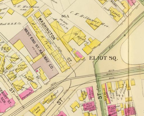
The Definitive Fort Hill Map Collection by Jason Turgeon

I keep finding great new maps of the hill and Roxbury in general, so rather than writing a post for each of them I’m putting together this summary post for easy reference.  I’ll add new links as I find them.

If you have a link to a map of Fort Hill that I’m missing (especially any between 1931 and today), please let me know in the comments!

Maps of the Siege of Boston:  The earliest maps I’ve found are all of the Siege of Boston.  Because of our hill’s prominence in the Siege, various parts of Roxbury are represented on all of these beautiful old maps.  Had we not been involved in this military effort we’d be lucky to have even one map of this quality from the 18th century.  The First Church is represented on most of these, and some of them show a cluster of buildings around Dudley Square.  Many of them show one massive fort, not the two distinct upper and lower forts that we know were here at Highland Park and on the hill next to Kittredge Square.  In most of these, the scale is nonexistent, but they are all beautiful.  At this time, Roxbury was a tiny farming village of perhaps 2,000 people. 

19th Century Roxbury until its annexation:  In these maps, we see Roxbury go from a tiny town of 2000 people to a full-fledged industrial city of perhaps 40,000 or more by 1868.  The quality of the maps also improves dramatically over a short period of time.  I’ve excluded a number of maps that show only a portion of Fort Hill or that lack any meaningful detail.

  • 1814: A Plan of those Parts of Boston and the Towns in its Vicinity: with the Waters and Flats Adjacent (Mass Historical Society). This map by Benjamin Dearborn (1754-1838) is a proposal to construct what he called “Perpetual Tide Mills” across the Back Bay and South Bay in Boston. The plan details water and marshland as well as streets and roads of Boston, Roxbury, Brookline, Charlestown, Cambridge, Brighton, and Dorchester.
  • 1832: Map of the town of Roxbury (Leventhal Map Center).  The first map in my collection dedicated to Roxbury and covering the entire town, which then included West Roxbury, Jamaica Plain, and Roslindale.  Another version of this map is available at the JP Historical Society.  A small fold-out version of this map was included in Drake’s History of Roxbury.  This is the first map to show  Highland Street, which was laid out shortly after the “five investors” purchased their large tract of land on top of the hill.
  • 1843: Map of the town of Roxbury, surveyed by order of the town authorities (Leventhal Map Center). What looks like an update of the 1832 edition, but by a different author.  A great map to show the rapid growth between during that decade.
  • 1849: Map of the city of Roxbury (Leventhal Map Center). An updated version of the 1843 map.  This is the first map after Roxbury became a city in 1846, and shows the wards of the new city.  This is also the first map where we see Fort Ave.
  • 1852: Map of the City of Boston and immediate neighborhood (Leventhal Map Center).  An absolutely gorgeous map that shows our neighborhood in its entirety.  This is one of the first maps to show individual property names and building outlines.  It also features etchings of 55 buildings from around Greater Boston around the perimeter of the map.
  • 1860: Roxbury (WardMaps.com) A basic street map without much other detail.

Roxbury from 1868 to the 1930’s:  After Roxbury became a part of the City of Boston, it continued its massive growth even as it shrank to its present diminished size.  By 1940, Roxbury had grown to a population of about 140,000.  

A number of these maps are insurance atlases.  These were produced to help insurance companies decide where to write policies and how much to charge for them.  The atlases typically have a very small scale and use many pages to cover a neighborhood.  Building outlines, street names, ownership, and many other details are rendered in exacting detail.  In these atlases, the pink buildings are generally brick and the yellow ones are wood frame-an important distinction for someone considering whether or not to write a fire insurance policy on a particular building!

UPDATED 3/18/2012: Thanks to Mark for the tip on several more atlases available at mapjunction.com, where the atlases have been stitched together and overlaid on current imagery so you can much more easily find what you’re looking for and see changes over time from 1883 through 1931

http://www.mapjunction.com/bra

It takes a little work to figure out, but once you do you can toggle among multiple fire insurance maps for the same site. Follow these links:

New Flash Viewer > wait to load, then:

Add Layer Group >

Boston Public Library >

Bromley Atlases >

Roxbury

That’s pretty much all I’ve got until we get to the modern maps - there’s a huge hole in my knowledge of the neighborhood from 1931 until the present day.  Sadly, much of this is due to insane copyright terms, but that’s a story for another day.  But there are a few other maps worth noting:

If you have any access to maps from the years in between 1931 and 1988, I’d love to see them.  And if you find anything at all that covers a significant part of Fort Hill, please send me a link or leave one in the comments so I can keep this up to date.

The Boston Nursery for Blind Babies by Jason Turgeon

One of the things Stephen sent me was a partial scan of an old article about something called the Boston Nursery for Blind Babies.  A little digging quickly led me to the full article on Google Books in the March, 1905, edition of New England Magazine.

The article says the Boston Nursery for Blind Babies was started on January 1, 1900, by Bertha Snow (the article’s author), who had taught at a kindergarten for the blind in Hartford, CT, and been struck by the need for services for younger blind children.  Oddly, the Boston Center for Blind Children, the successor organization to the nursery, has a conflicting story stating it was founded by Isabel Greeley in 1901.  

Regardless of who started the nursery, the crushing poverty, long work hours, miserable housing conditions, and lack of education among the working classes led to a common but preventable disease that affected the eyes of newborns.  If the disease was caught quickly, it could be cured by most doctors, but many families lacked the means or education to see a doctor and there were blind babies hidden away all over the slums of America’s cities.

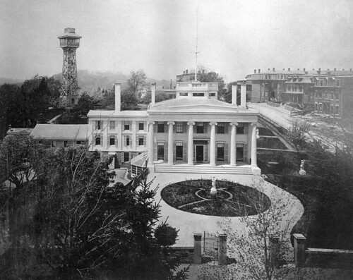
Ms. Snow raised the funds for the first nursery in a ten room house in Egleston Square, but quickly the demand for her services pushed her into a larger 15-room building at 66 Fort Ave, in the house shown above.  She was there from about 1902 until 1909.  Unfortunately, the 1906 map available at Historic Map Works is missing the page that has Highland Park and the property on Fort Ave., but the 1915 atlas shows the building.  

The building was located on what is now the lawn behind the relatively new townhome development on the corner of Beech Glen and Fort.  

The New England Magazine article paints a depressing picture of life at the turn of the century.  Here’s an example:  

The first inmate to arrive was a little colored boy two years and a half old. He had been found tied into a chair in a basement kitchen. His mother was obliged to go out to work by the day to support herself and children so she tied the little blind fellow into a chair that he might not run against things and get hurt. She told me that she gave him some bread and butter and coffee in the morning before she went to work and that she aways left plenty of doughnuts on the table near him so he could put out his hand and find them when he was hungry. Unable to move about and with no one to attend to his needs the little fellow sat tied into his chair alone day after day and week after week with nothing to occupy his time or attention nothing to eat but baker’s bread and baker’s doughnuts and nothing to breathe but the foulest foul air.

The tale gets worse from there, ending with the unfortunate young lad dying despite many months of efforts to save him at the nursery.  It’s easy to romanticize the steampunk era of 125 years ago until you read a story like that.  In a world where working-class parents had little or no education, often barely spoke English, had many children, and worked 60 or more hours per week, attending to the needs of a blind child was rarely a possibility and many of these children were consigned to miserable lives.  

Fortunately, the nursery had many more successes after its early experience.  In some cases, they were able to restore the sight of the young children through surgeries or improved nutrition.  In most others, they were able to bring the children to normal function, teaching them to speak, walk, eat, and clean themselves.  Once the children turned 5 they were sent on to the well-established Perkins School for the Blind, an institution that still exists in Boston today.

But by 1909 the Nursery was growing again, and that year it started construction on its final home on South Huntington Ave next to the Home for Little Wanderers.  By a wonderful coincidence, Remember Jamaica Plain picks up the story in a post about the creation of South Huntington.  Click through to read about the creation of South Huntington Avenue, including a transcript of a 1909 newspaper article about the buildings along the street, and see the site of the Nursery in a later map.

Fortunately, the need for services like the Nursery ended as medical services and education improved.  The home transitioned to more and more specialized services for children with greater levels of need before eventually closing in 1995 and reorganizing itself as a non-profit called the Boston Center for Blind Children.

Before I wrap up, I’d like to paste in this article from the Unitarian Register, September 24, 1903.  Although it doesn’t add any crucial info to the story of the nursery, it was written by local celebrity Edward Everett Hale, and that detail combined with the sweetness of the story itself make it worth sharing.  If the article is too hard to read, click through for the google books version where you can zoom in.

Photos from Stephen by Jason Turgeon

Stephen Walker, former owner of the South End Photo Lab and former Fort Hill resident, has generously provided me with top quality scans of a whole cache of photos, postcards, and newsclippings that he collected during his years on the hill.

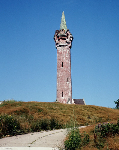
fort hill tower 1970s

He’s started an ebay store where you can buy 8x10 prints of many of these photos.  You can bet that after running one of the most beloved photo labs in the city for many years, the quality of these prints will be well worth the $10 or so he’s charging, so take a look at his store and pick up a couple for your wall.

kittridge sq

Over the coming weeks, I’ll be posting these photos as fast as I am able to research the stories behind them.  Thanks, Stephen!

Black History Highlights of Fort Hill by Jason Turgeon

In honor of Black History Month, I thought I’d take a stab at recapping what little I know about our neighborhood’s relatively recent black history.  I’m almost certain to miss important events and people, so if I missed something, please give me details in the comments.

Most people think of Roxbury as a neighborhood that is majority African-American, but it wasn’t always that way.  In fact, it was only in the second half of the Great Migration that Roxbury, especially Fort Hill, became home to a large black population.  But its black history does go back to the earliest days of the town.

Fort Hill’s black history, like the rest of the new world, starts with the slave trade.  Slavery was documented in the colony as early as 1624, well before the founding of Boston or Roxbury.  Many people in the Boston shipping industry participated in the slave trade, and Roxbury was not immune.  The National Park Service has a guide (PDF) that does a nice job recapping what little we know about slavery in Roxbury. Dr. Joseph Warren, whose name lives on in Warren street, owned a slave, as did General John Thomas, of the Dillaway-Thomas house at Eliot Square.  Roxbury counted 22 slaves aged 14 to 45 in 1771, but chances are that the number was higher because of the way they counted for tax purposes.  But there were also at least 4 free black couples living here at the time.  

For a more in-depth look at slavery in Massachusetts, the website slavenorth.com has a good summary, and the Massachusetts Historical Society has a great set of documents and info about the end of slavery in 1783 at this link.

One problem with trying to track black history anywhere in the US is that there simply aren’t many records related to black people in the early days of the country.  Racism was still endemic, even after the Massachusetts Supreme Court decision in 1783 that ended slavery in the Commonwealth, and black people rarely owned property or businesses, so they didn’t leave much of a paper trail.  But we can get hints as to what life might have been like for the handful of black residents in our neighborhood from places like the Journal of a Residence and Tour of the US, written by visiting British author Edward Abdy when he visited the country in 1833-4.  

Throughout the book he takes a hard look at slavery and the treatment of free blacks, and his visit to Boston, recounted in chapter 5 of the book, is no different.  As he notes on meeting some black men at an anti-slavery meeting he attended

There were several of the same race present; all of them decent in their dress and decorous in their behavior. Some of them appeared to be in easy circumstances. There are fewer of them in Boston than in New York; but they are not better treated. One of them complained to me that he had experienced, great difficulty in obtaining an employment in which he could get his bread decently and respectably: with the exception of one or two employed as printers, one blacksmith, and one shoemaker there are no colored mechanics in the city.

It’s a fair assumption that the circumstances for blacks in Roxbury weren’t any different.

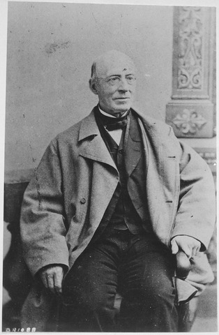
Abdy was a contemporary of William Lloyd Garrison, our neighborhood’s famed abolitionist and the author of the Liberator.  I’ll write a full post about Mr. Garrison somday.  For now, I think it suffices to mention his involvement in bringing about the end of slavery nationwide and simply link to his bio on wikipedia.

William Lloyd Garrison

After Garrison, there’s not much info on the neighborhood’s black history for many decades.  As Fort Hill changed from a bucolic suburb into a densely populated city with its own industry, it stayed largely white.  The neighborhood was sometimes called “German Hill” because of the thousands of German immigrants who lived here 100 years ago.  But given the industrial workforce and the many blue-collar jobs available at the time, it’s a fair guess that there were at least some black families living in the area.  We certainly know that there was a community of Caribbean immigrants around the turn of the last century that congregated at St. Cyprian’s in Lower Roxbury, including the Roxbury Aunties.

But the neighborhood’s changeover to a largely African-American population didn’t happen until the 1940s.  Census records from 1930 onwards are available online at the BPL, and although there isn’t one census tract that neatly encompasses Fort Hill, we can use Roxbury as a whole as a proxy.  Here’s what Roxbury looked like in 1930 - 48% of its residents were white immigrants fresh off the boat, another 20% or so were the children of immigrants, 15% were whites who had been in the country at least 2 generations, and about 15% were black.

Unfortunately, there’s no similar analysis for the 1940 census, but we do have access to some data from the 1950 census.  In the intervening 20 years, Roxbury stayed largely white.  Of the 112,000 people in the neighborhood in 1950, just under 26,000 were listed as “non-white.”  

By 1960, though, things had changed dramatically.  The overall population had fallen by nearly 25%, to 85,000, and the non-white population was at about 38,000, or just about 45%.  Sadly, an increasing black population was closely tied to a decrease in income, status, and services in the neighborhood.  By the end of the 1960s, Fort Hill was a desolate place, bordered by the wastelands that remained after the failed urban revitalization and transportation projects of the era.  Our once-beautiful housing stock fell into disrepair, our parks were neglected, and even the neighborhood’s most prominent landmark, the Cochituate Standpipe, was not immune to decay.

Cochituate Standpipe on fire, 1960s

By 1970, Roxbury was firmly an African-American community, with the census listing about 41,000 blacks out of a total of just 63,000 remaining resident - a decline in overall population of almost 50% from its prewar peak.  But while the neighborhood was in decline overall, the seeds of something great were being sown in Fort Hill.  Community-minded groups took advantage of the rock-bottom prices, prime location close to Boston, and some remnants of civic pride to salvage the neighborhood.  

One of the most prominent of those groups was the Roxbury Action Program, which wanted to form a “model black community” under the charismatic leadership of George Morrison.  Their story is detailed in Stewart Perry’s marvelous history of RAP, which is partially available online.  I was lucky enough to find a copy of the original book on eBay, and I hope to write a much more detailed post about RAP at some point in the future.

RAP, with help from many other groups, was able to stabilize the neighborhood and save many of the old buildings from destruction, including the Norfolk House and several blocks of rowhouses.  It’s not entirely clear that they succeeded in their vision of creating a model black community in Fort Hill, but many of Boston’s black leaders have called the area home, including Chuck Turner, Byron Rushing, Ed Cooper, Celia Grant, Darryl Settles, Derek Lumpkins, and others.  

Recent historical information is always a bit harder to find online, both because of copyright issues and because many people don’t think of recent events as “history” yet.  But if you want more, check out the oral history project housed at Northeastern University.  The archives at Roxbury Community College are also a good place to start.

What happens next for the Black History of Fort Hill remains to be seen.  While some worry about gentrification and an influx of affluent white newcomers, it’s worth noting that even in the darkest years of the 1970s and early 1980s our neighborhood always remained more integrated than other parts of Roxbury.  Black and white neighbors have formed a tightly-knit community over the past 30 years that transcends race, a sad rarity in a town that is still largely racially divided.  Hopefully this continues, with newcomers augmenting a great community, not replacing it.

Commodore Samuel Lockwood and his house. by Jason Turgeon

I came across this photo in the BPL Flickr stream and decided to hunt it down:

Houses: Highland Sockwood House, Highland St., Roxbury

The picture is labeled “Highland Sockwood House, Highland St.”  A quick look at the 1873 map for Highland St. shows that there wasn’t a “Sockwood” family but there was a house owned by Maria Lockwood that certainly seems to fit the bill.

Maria Lockwood was the wife of Commodore Samuel Lockwood, a major figure in the US Navy.  Born in 1853, he distinguished himself as a midshipman in the 1820s fighting pirates off the coast of Greece.  He rose to prominence in the Mexican War and was promoted to Commodore in 1857.  He commanded the blockades of a number of Southern ports in the Civil War, mostly around Virginia and the Carolinas.

Maria, incidentally, was born Maria Dunbar in New Bedford.  Her Daughter, Maria Dunbar Lockwood, was married at the house to Clarence Westcott on June 17, 1890.  Mr. Westcott was a New York lawyer and it seems likely they returned to New York after the marriage, but the house was clearly an important part of the family for decades.

I haven’t been able to find out much about the Lockwood family’s time in Roxbury, although there’s plenty of info available about the rest of his life.  A good place to start is at this appendix to the Lockwood genealogy that is dedicated to his military career.

The Lockwoods were evidently living in Boston by 1853, when their son Thomas was born here as the 4th of their 5 children.  His little sister Emma followed in 1858, also in Roxbury.  By the time of his death in 1893 at the age of 90, the whole family was living in and around New York City.  The house remained in the family until at least 1895, but by 1915 the beautiful old building was gone, replaced by the large apartment block that is still at Kittredge Park today.

The Trimont Tool Company by Jason Turgeon

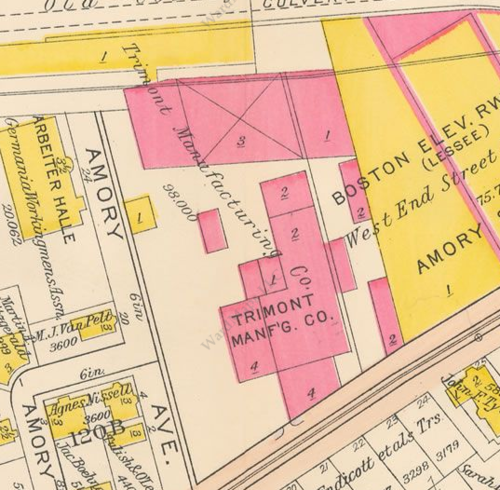
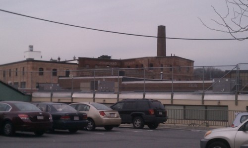
The Trimont Tool Co. wasn’t technically on Fort Hill with its location at 55-71 Amory Street in JP, but it was so close that I can see it from the rear of my house on Beech Glen Street now that the leaves are off the trees.  

The Trimont factory on Amory Street in 1915.  The building is still standing and is better known for its predecessor, the Rockland Brewery.  It was the original home of Bikes not Bombs and was for many years used as artists lofts.  Below is a picture of it from Columbus Ave near the Dimock Hospital.

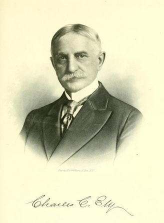
After the Rockland Brewery closed in 1902, the Trimont Tool Company moved in.  The company, owned by the Ely brothers, was famous across the country for its high-quality wrenches and pipe-fitting tools made under the Trimo name.  The tools were built to last, and you can still find serviceable pipe wrenches on eBay for about the same price as you might pay for a more modern version.  I’m happy to say that I was able to pick up a wood-handled 8” wrench that I would be glad to use on a plumbing job for under $10 shipped.  It’s so strange to think that they used to make tools like this across the street.  

A 100-year old Trimo wrench

The company was well-advertised, and you can find old ads in Scientific American magazines from the 1910s and 1920s easily enough.  Here’s a typical ad from 1924:

Trimont Ad

One of the interesting things about the Trimont Company was its role in labor disputes in the early part of the 20th century.  At the time, working conditions were terrible across the country and unions were making rapid inroads.  Here’s a letter written in opposition of a proposed 1902 law that would have required companies supplying equipment to the federal government to have given their workers an 8-hour workday.  It was written by Charles Ely, who took over as president of Trimont just a few months earlier after the death of his brother Edward.

I would expect that some of the men who worked in the factory lived in our neighborhood, probably along Ritchie Street, Marcella Street, and the lower end of Highland. It’s comforting to think that after their 10 or 12 hour workdays, they could stop by one of our local breweries and saloons for a pint before heading home.

But despite his hard-nosed business tactics, Charles Ely had a softer side.  He published a book of poetry that is available online called “The Image Maker and Other Poems" which is a must-have for the Roxbury historian, although I’m not sure poetry lovers will feel the same way.  It’s not so hard to imagine him sitting on a hill somewhere in Roxbury with his quill pen writing his odes to nature.  Click the picture for a link to his biography.

The company stayed in business until 1954, when it appears to have been sold.

The Roxbury (Boston) Boys Club by Jason Turgeon

On my walk with the dog this morning, I noticed the “Boys Club of Boston” at the end of Dudley Street across from O’Aces barber shop.

A quick trip to Google shows that this was the original Roxbury Boys Club, founded in 1910, which merged with the Boston Boys Club in 1932 and eventually became the Boys and Girls Club of Boston in 1981.  This venerable institution now has 10 clubs around Boston and serves over 14,000 boys and girls.

This picture from the club’s history page for Roxbury shows the building about the time of the name change.

Boys Club about 1932

You can see that before the urban renewal campaigns of the 1960s, the Boys Club building used to be in the middle of the block, with parking to the east and more buildings beyond those.  All of that was torn down around the time of the Madison Park destruction in 1966, and now the building abuts the Shawmut Avenue extension.  The club left in 1968 for its current home on Warren Street after the BRA notified club management that they would be taking the building by eminent domain.  Fortunately, the destruction stopped just short of this building.

The Roxbury clubhouse didn’t officially open until 1916, but the building was far enough along in construction to appear on the 1915 Ward Map.

Happily, the building has been restored and today carries on as a center for young people as the home of the Roxbury branch of the Youth Advocacy Department.

The current club management has an excellent history compiled from old board meeting minutes.  The original (.doc) version is here, but I’ve taken the liberty of copying the text below in case that ever disappears.

Roxbury Club: An Early History

The roots of today’s Yawkey Club of Roxbury can be traced to the merger of three smaller organizations dedicated to getting boys off the street, under the leadership of James B. Stewart. In a series of room within the People’s Institute at 1173 Tremont Street, Mr. Steward provided entertainment, recreation and a variety of industrial arts, and on certain afternoons, admitted girls to the Club.

As in Charlestown, the young boys of Roxbury were eager to become part of an organization that was designed especially for them. Membership swelled, and in June 1900, the Institute moved to newer, larger headquarters at the corner of Ruggles and Tremont Streets. Provided by Robert Paine, the same benefactor who had offered the rooms on Tremont Street, the new Club was a three-story brick building.

Although the Institute helped to alleviate some of the issues faced by Roxbury youth, it was obvious that additional facilities were needed. Judge Nathan A. Williams succeeded in enlisting the interest of a number of prominent Roxbury citizens, and at a meeting in the Roxbury Courthouse on January 24, 1910; he suggested that a Boys’ Club be formed in Roxbury. 

With the support of the citizens group, rooms were secured at 2373 Washington Street, and a new Boys’ Club opened. After several months, however, the Club’s directors decided to sell the furniture, tools and other equipment and close the doors.

Later that same year, another meeting was held, and Mr. Stewart proposed that the Roxbury Boys’ Club be merged with the Boys’ Institute of Industry. After some discussion, a new name was chosen for the merged group, the Roxbury Boys’ Club.

Soon the problem of space once again became a major concern. A committee from the new group purchased the Jackson estate on Dudley Street, and a campaign was organized in 1914 to erect a new building large enough to meet the needs of all the boys of Roxbury. During the campaign, pledges amounting to $75,000 were secured. In 1916, the new Club at 80 Dudley Street went into full operation. By 1917, there were 2,500 boys enrolled.

On January 21, 1925, at a meeting of the Directors of the Roxbury Boys’ Club, it was proposed that this Club should combine with the Boys’ Club of Boston, Inc., so that both of these organizations, which had similar purposes, might serve the youth of Boston more effectively. Committees were appointed from both Clubs to study the proposal.

At a meeting on January 28, 1927, the committee presented its proposal, calling for “the advisability and expediency of closer relations.” They voted unanimously to accept “closer cooperation between the two Clubs” and “common management through common officers.”

George Bramwell Baker was elected as the first President of the combined group, Harris G. LeRoy, was named the first Executive Director, and a Board of Directors of 28 men was formed.

The final step in the merger occurred on March 30, 1928, when the Supreme Judicial Court authorized the Roxbury Boys’ Club to transfer its property to the Boys’ Club of Boston. The addition of another unit necessitated another name change, and, on April 18, 1932, the organization became known as The Boys’ Clubs of Boston, Incorporated.

During 1940, 1,656 families moved out of Roxbury as a result of Federal Housing developments, greatly effecting Club membership. However, the Roxbury Club provided an important function during the next few years, as Army and Navy units received swimming instruction in the pool.

By 1963, the Club’s programs extended from the early classes in woodworking and printing to classes that taught carpentry and sailing. Early programs in simple gymnastics evolved into extensive physical fitness programs that featured trampoline, basketball, swimming, bowling, hockey and other outdoor activities. 

At the same time, Boston was being revitalized by urban renewal and an ever-changing skyline, and the Boston Redevelopment Authority (BRA) notified the organization that the land on which the Roxbury Club was located might be taken for the building of a regional school. As planning progressed, the BRA offered a site on Warren Street for a new Club adjacent to the proposed new Roxbury government center. For most of this decade, negotiations with the BRA continued as numerous permitting delays plagued the project, and estimated construction costs kept rising.

In 1966, a detailed construction plan was finally approved, including “adequate classroom and library facilities to meet the direction that education programs are taking in the future.” Construction began in the fall of 1966, and The Boys’ Clubs of Boston held its Annual Meeting at the Roxbury Clubhouse on April 30, 1968. The Club building became fully operational and was dedicated in June 1968.

Josiah Banks and the Goodyear Vulcanite Denture Patent Murder by Jason Turgeon

A few months ago, I wrote about the trials and tribulations of Charles Goodyear and his quest to make a useful rubber product.  That quest ended up with the development vulcanized rubber, which quickly found uses in just about every industry in the rapidly industrializing company, but only after a variety of patent battles.

So imagine my delight when I found that the most recent edition of the podcast 99% Invisible was based on the Goodyear Dental Vulcanite Company!  It concerns the 1879 murder of Josiah Bacon, an early patent troll who pushed a dentist using the Goodyear product to the brink.  It’s worth a listen, even though the whole story takes place outside of Fort Hill.  Enjoy!

The William Bailey Lang Cottages by Jason Turgeon

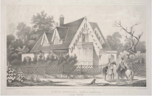
As I’ve been searching for clues to the history of the ‘hood, I keep running across variations of a brief 44-page book called Views: with ground plans of the Highland cottages at Roxbury (near Boston).  It was written by one William Bailey Lang and contains a handful of “cottages” (actually fairly good-sized single family homes) that Mr. Lang built around our neighborhood between 1837 and 1845.  

Here’s the Bute Cottage, where he may have lived for a time.  Below it is the 30’ high observatory in the woods at Bute Cottage.  What, your cottage doesn’t have an observatory with views of “Boston, Cartridge, Charlestown, Chelsea, Dorchester, the Ocean, and the Hotel at Nahant?”  There were also 4 outbuildings - a pumphouse, children’s playroom, carpenter’s shop, and a “rustic bower.”  

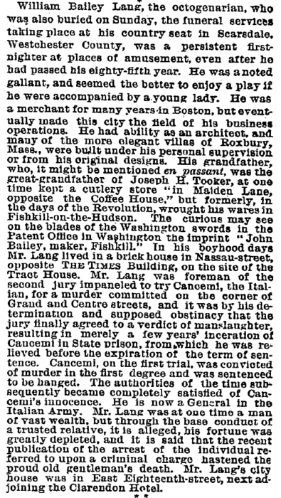
Trying to find out more about Lang or his cottages has been a bit frustrating, but I have been able to dig up the basics of his life from the two obituaries reproduced below.  In summary, he was a merchant who sold iron imported from England, first in Boston until about the 1840s and then in New York.  He was also an amateur architect who designed not only these cottages but also a magnificent house in Scarsdale, NY, that is today home to the Scarsdale Women’s Society.

But what about the cottages?  So far, I haven’t been able to find a map with owner’s names any earlier than 1873, decades after he left the area, and in my walks around Fort Hill I haven’t been able to positively ID any buildings that might be one of his.  Most likely they are all long since destroyed, but if you happen to know of a cottage that might be one of his and is still standing, or if you know where any of them were, please get in touch!

Apologies that these are rotated 90 degrees.  It’s how they appear in Google Books and it’s much easier to paste them this way directly from Google than it is to do screengrabs, editing, and relinking.  

Obituary 1:

Click through to get to the original where you can enlarge it.

Obituary 2:

Click through for the PDF version from the NY Times, August 1, 1887.

Roxbury Heritage State Park Master Plan by Jason Turgeon

Click the link above for a trip back in time to the dawn of the Roxbury Heritage State Park. The park, originally conceived of by the Roxbury Action Program in the ’70s, finally came to fruition at the end of the 1980s.  Sadly, it never got all the funding the planners hoped for.  In particular, the incorporation of the Owen Nawn Factory on Washington Street as a permanent exhibition center for Roxbury History never came to fruition, and the building is now only about 1/3 of the size it was then.  Hopefully Historic Boston Inc., with new headquarters right next door to the Nawn Factory, will be able to help.

William Lloyd Garrison avoids a lynching by Jason Turgeon

I haven’t written much yet about Mr. Garrison, one of our neighborhood’s most famous residents.  He’s famous for being a passionate advocate for the abolition of slavery and for publishing the abolitionist newspaper the Liberator.  I found this clip in a book called Some Interesting Boston Events and since it’s such a wonderful piece of history I figured that rather than summarizing the story I’d share the whole thing.  Enjoy!

Caleb Fellowes and the Fellowes Athenaeum by Jason Turgeon

Every once in a while life tosses you a bone.  Such is the case with the story of the Fellowes Athenaeum, Roxbury’s first library.

Fellowes Athenaeum

The Athenaeum, a gift of the estate of Caleb Fellowes, opened with much fanfare on July 9, 1873.  How much fanfare?  Enough to warrant printing up a 30+ page guide to the services with all the info an armchair historian could ever want about the building and the man it’s named after.  Thank you Google Books!

The capsule version is pretty entertaining.  Caleb Fellowes was born in Gloucester on July 9, 1771, 102 years to the day before the dedication of his athenaeum.  His father married Sarah Williams of the well-known Roxbury clan.  The Fellowes family had many other ties to Roxbury, and there were various cousins and other relatives of Caleb living in Roxbury at least into the 1860s.  His uncle Gustavus Fellowes was the sort of fellow (sorry, I had to do it) we’d call a “shipping magnate” these days.  He married Hannah Pierpont, whose family owned the gristmill on the Stony Brook about where Roxbury Crossing is now, and for years that branch of the Fellowes family lived in the legendary Pierpont Castle, also called Dearborn House, that sat where the Mission Church now resides on Mission Hill.  There were plenty of other Roxbury connections in the family, but for now we’ll stick to the story of Caleb.

Young Caleb picked up a love of the ocean and against his parents’ wishes hopped a boat bound for China when he was about 16, which would have been about 1787.  The Fellowes genealogy picks up the story nicely:

[He] was working as a mate on the ship “Fair America” out of Boston under command of Captain Lee when for reasons unknown he was set adrift in the middle of the ocean near Cape Good Hope around Apr/May 1792 with one other man. He was picked up by a ship bound for the East Indies where he became a pilot in the China seas. Under the name “Captain John Williams”, he met a native east Indies woman, who fell in love with him. She promised her fortune to him if he would marry her. They may have had several children. To the great surprise of family and friends, who thought him long dead, Caleb returned to Boston and later married Sarah Carver, his land lady in a marriage of conveince. They settled in Roxbury, MA in 1816. While living in Philadelphia he received a letter requesting him to come to India to take possession of the property left by the woman he had lived with. 

Caleb got his name into the Journal of the House of representatives from 1811 when he wanted to bring his stuff back from India, and since Nathaniel Ruggles also apparently had some stuff on the same boat it’s likely that they had been in communication for some time before he returned:

Rev. Putnam tells us that Caleb came back to the states in 1812, so the fact that he was able to disappear for about 25 years then send a letter back home asking for his family to help him come home and have that family make arrangements in the US Congress to do so should give you a bit of a sense of the type of people the Fellowes were.  Definitely not your lower class merchants.

Anyway, Caleb came back, but spent a few years in Philly where he married Sarah Carver.  This is contrary to what the genealogy states but I’m trusting Reverend Putnam on this one, even though the reverend botched the math and reported Caleb to be 53 when he was married - he would have been 43 in 1814.  In 1816 the couple moved to Roxbury into a house on the corner of Washington (then called Shawmut) and Bartlett, right about where the old Cadillac dealership is now, across Washington from the new police station.  

Mr. and Mrs. Fellowes hung around Bartlett Street until 1834, and during those 18 years he evidently became great friends with Supply Clapp Thwing.  Keeping in mind that Thwing was born in 1798, 27 years after Fellowes, the circumstances of this friendship are a bit murky.  Then for some reason Fellowes got the urge to go back to India, and so at the tender age of 65 he sold his house, packed his bags, and sailed halfway around the world with his wife.  Apparently you can’t go home again, because the next year he gave up on India and moved back to the US, but this time to his wife’s hometown of Philadelphia, where he lived until he died at the age of 82.

Fellowes Athenaeum Branch of the Boston Public Library

At this point in the telling of the story of Caleb Fellowes, Reverend Putnam took the time to ask why on earth an 82-year-old man living in Philadelphia who had lived less than a quarter of his life in Roxbury and hadn’t been there in nearly 20 years would leave $40,000 (a massive sum in those days) to start a library in Roxbury.  The answer, it turns out, is his friendship with young Mr. Thwing.  Apparently Fellowes originally intended to leave the money to Thwing instead and Thwing talked him out of it and asked him to use it to found the athenaeum instead.  Think about that for a moment.  If a dear friend of yours, who happened to be much older and filthy stinking rich, wrote you a million dollars in his will and you found out about it, would you tell him to give the money to charity?  

But there’s a final chapter to the story.  Fellowes made very specific instructions in his will that the building be built within a half-mile of the First Church, be modeled after the Philadelphia Athenaeum, and that the leftover money be invested with the returns used to buy books.  But there’s a bit more to the story.  It turns out that by the time Caleb died, $40,000 wasn’t quite enough money to do what he’d asked.  So the trustees of the fund, which read like a virtual who’s who of Roxbury citizens including JF Osgood and William Whiting along with Thwing, Putnam, and others, sat on the money and tried to invest it wisely.  They were for a time planning to have the building somewhere around Bartlett Street.  And then suddenly the long-awaited merger with Boston happened, and with it came the improvements that Roxbury had been begging for - like public libraries.

And here something remarkable happened.  Common sense prevailed, and the Fellowes trustees and the City of Boston came to an agreement.  The Fellowes fund - by then augmented by further money after Sarah Fellowes died and left more to the trust - was used to buy the land and building.  The City rented the library and the trustees used the rent to pay for insurance and other expenses.  Both parties bought books, marked them in case the agreement ever fell apart, and shared the space as one library.  So the City was able to get a magnificent new library to place in the heart of the wealthy new suburb it had just acquired at a fraction of the normal cost, and the Fellowes Trust was finally able to achieve its goals.

The agreement lasted for over 100 years until 1978, when the City opened the Dudley Branch on Warren Street and closed both the Fellowes Athenaeum and the Mt Pleasant branch library.  Today, the building is the home to the Refuge Church of Christ and is sadly in need of renovation in spite of a recent grant to perform some work.

Refuge Church of Christ

Who was David Hodgdon? by Jason Turgeon

Most of us living in Fort Hill are familiar with Hodgdon House, the large mansion on the corner of Highland Street and Hawthorne that is sadly neglected and falling apart.  It was used in the recent movie “The Company Men,” for which it received a coat of paint on the two sides that were filmed.  

The house is known as Hodgdon House after David Hodgdon, its first occupant.  It took some digging, but here is a little bit more info about the David Hodgdon.  There is some info about the house in the Boston Preservation Alliance’s 2009 report on Highland Park (PDF), but there are some inaccuracies.  For one thing, the house was not built by Supply Clapp Thwing, although Thwing owned a very similar house across Highland Street.  For another, Supply Clapp was not the son of Supply F. Thwing as stated.  But the overall report is pretty good, so if you want to know more about the house I’ll point you there instead of repeating it here.  The section on Hodgdon’s house starts on page 15

But as interesting as the house is - and it IS interesting, with a long and colorful history that is pretty well documented in that report - I wanted to find out more about Mr. Hodgdon himself.  So far, I’ve been able to dig up the skeleton of a portrait.  His full name was David Miller Hodgdon.  His father was John Hodgdon, of Belfast, Maine, where David was Born.  He manufactured clothes at a facility on the corner of Otis and Arch street in downtown Boston and was evidently very successful.  He married Henrietta Young, the daughter of a successful merchant family in Orleans.  He owned a pew in the First Church, and was important enough to the Church to get his name inscribed on a plaque with a limited number of other luminaries.  He died in Roxbury on May 17, 1894, at the age of 67.

I’ll leave you with a note about his business from an 1892 guide to Boston’s finance.

1851 Report of the Committee in Favor of the Union of Boston and Roxbury by Jason Turgeon

In the late 1840s and early 1850s there was a raging battle among the eminent citizens of Roxbury - almost all of whom lived in our neighborhood - about whether or not Roxbury should join up with Boston.

The side in favor of Roxbury’s independence was led by Samuel Guild, the prominent merchant whose name lives on in Guild Row at Dudley Square and Guild Street to the south of the Bartlett Yard.  I’ll have a post about the Guild family eventually.

The side in favor of annexation was led by William Whiting with backing from a number of Roxbury landowners and businessmen including George Simmons, one of the 5 original developers of the Highlands.

At some point in 1850 or 1851, Guild and his crew published a treatise called “A word for old Roxbury,” which despite being referenced in a number of places around the web I can’t find online.  It was a defense of Roxbury’s continued independence, and elucidated the many reasons why the two cities should not merge.  One of those reasons was undoubtedly civic pride and an unwillingness to see the end of  a city that many people had grown up with.  But there were also concerns about increased taxes, water and sewer bills, home rule, and questions about whether or not Boston could deliver the services it promised to such a large new territory.

In response, Whiting et al. published this report.  The authors spend 31 pages plus an appendix rebutting Guild’s document point by point.  It’s a slow, laborious read at times but it also provides a great deal of insight into the conditions of Roxbury at the time.

Roxbury was growing by leaps and bounds from a tiny farming community into a major metropolis in its own right and had recently switched from town government to city government.  The town had no public sewers or water supply, no public parks, muddy roads covered in filth, and in the lower sections near the tidal flats conditions in the tenements were absolutely deplorable.  

Boston had recently spent over $500,000, an extravagant sum at the time, building the Cochituate Reservoir and the water mains to bring water from it to Boston and the recently annexed East Boston.  Boston was also an early innovator in the construction of gravity sewers, leading New York in this major public health improvement. Roxbury relied on the Jamaica Pond, the increasingly polluted Stony Brook, private wells, and cisterns for its water needs.  Its citizens used outhouses, or perhaps simply dumped their chamberpots in the streets in the slums on the low-lying land around Boston Neck.

But the group in favor of annexation was also upset by a long list of other grievances.  The short version is that they felt that the City government was not providing for the general public good.  They were upset that the City had no parks, no public water, no sewers, no plan for paving roads, no mandates for sidewalks, no plan to manage growth, or any of the other things that residents of Boston enjoyed and that we now take for granted.  After over 220 years of independence, they questioned how much longer the city could wait and worried that if Roxbury did not soon buy open space and make plans to widen and improve its streets that the city would turn into a vast slum.  They were worried that property values in Roxbury would stagnate as other territories around Boston were annexed and received the benefits of these public services, and pointed to the rapid growth in East Boston - in both population and wealth - after it joined with Boston and received public water.

Eventually, of course, Roxbury became a part of Boston and immediately got access to Cochituate reservoir water - and a park - with the construction of the Cochituate standpipe in Highland Park.  But it took another 17 years after the publication of this report.  I can only imagine that in the central meeting points of Roxbury at Eliot Square, Dudley Square, Guild Row, and on the omnibuses that things were chilly between members of the two warring factions for decades to come.

The Osgood Family of Roxbury by Jason Turgeon

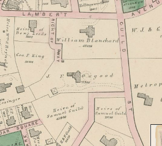
If you look closely at some of the old maps of Roxbury, like this page from the 1895 atlas, you’ll see the Osgood family name on just about every other corner.  This has intrigued me since I first saw an old Roxbury map because I’m a descendant of the Osgood clan - my great-grandmother was Louise Osgood, the daughter of a Joseph Osgood, a well-known preacher who lived in Cohasset in the mid-19th century. 

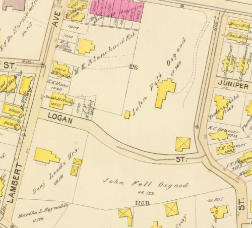
The John Felt Osgood mansion on Guild Street in 1873.  The Right-of-Way became Logan Street in the next map, bisecting the property.

The same property in 1895.  By 1915, Rockledge Street had been cut through the middle of his property and the mansion no longer existed.

It turns out that the Osgood family name’s pretty common, and that dozens of prominent Osgoods populate the history of our country.  Almost all of the Osgoods in this country - and there have been nearly 10,000 of them since the 1630’s, come from 3 Osgood brothers, all Puritans, who came over in the 1630s and settled in Andover, Essex, and Salisbury.  The eldest, John, has the largest pool of descendants, and it’s from him that both my great-grandmother and John Felt Osgood of Roxbury descended, but they were very distant cousins.  If you are interested in learning more about the Osgoods, the best place to start is OsgoodAncestry.org.  

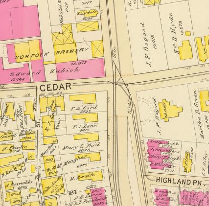
JFO owned properties at the corner of Centre, Cedar, and Fort

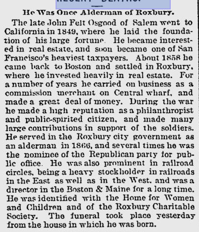
The Osgood that we’re most interested in Roxbury, however, is John Felt Osgood.  I haven’t found nearly as much as I’d like to about this man given his prominence as a landowner, but there are some details available online.  He was born to a seafaring family from Salem, Mass, on Dec 18, 1825, and continued the seafaring tradition by shipping out to the East Indies when he was 19 or 20.  After a few years there as a “commission merchant,” he ended up in San Francisco during the boom following the gold rush.  He was also a commission merchant in California, and apparently he was good enough friends with one George Comstock to have George name his son John Felt Osgood Comstock

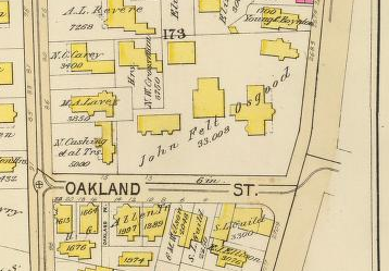
He also owned this complex of buildings on Oakland and Washington.

In 1858, John Felt Osgood came back to the east coast, but instead of returning to Salem he set up shop, once again as a commission merchant, at 25 Central Wharf and took up residence in Roxbury.  One genealogy has him listed as marrying his wife Elizabeth on his birthday in Philadelphia in 1854, and he’s known to have had several children with her.  

He quickly became one of Roxbury’s most prominent citizens, and he was evidently quite wealthy.  He was the secretary of the board of the Fellowes Atheneum, patented a process for coal-refining in 1870, was on a committee asked by the city of Boston in 1876 to investigate the best way to provide gas for streetlights (gaslights were run not on natural gas but on gas produced from coal or heavy oils under high heat), and was on the board of the Boston and Maine Railroad.  When the First Church celebrated the 100th anniversary of its current building in 1904, he was one of a very small number of men to have his name inscribed on a memorial plaque, along with luminaries like John Eliot, George Putnam, Charles Dillaway, and several Dudleys.  In other words, he was a Very Big Deal in Roxbury, and in particular in our neighborhood.

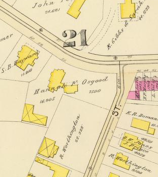
Besides the John Felt Osgood properties, there is this property belonging to Hannah F. Osgood at Cedar and Hawthorne where there is now a church.  It’s not clear who Hannah was from the Felt, Burling, or Osgood genealogies, but she must have been related.

He was also filthy rich.  When he died at the end of July in 1894, he left his wife and children with an estate valued at over $1,000,000.  That’s a large sum of money now, but it was an absolutely huge amount 120 years ago.  So it’s surprising to me that I haven’t been able to dig up more info on him.  If I find any more, I’ll post an update.  If anyone out there has any info that I’ve missed, please let me know!

UPDATE 1/5/12:  Found his obituary in the Boston Evening Transcript from Aug 3, 1894.  It has a bit more info, but not as much as I’d like.  I’ve also found a few old ads from the 1850s in San Francisco with his name in them as the agent for steamer sales, and it appears that he maintained property in SF until he died.
Old Roxbury Postcards by Jason Turgeon

A surprising number of old Roxbury and Fort Hill landmarks made it into postcard form in the first decade of the 20th century.  I’ve been able to pick up a handful of these postcards on eBay, most for just a few dollars.  But nobody has a collection quite like the one at CardCow.com.  I think they’ve found every single one of the old Roxbury postcards, scanned them, and put them online for us to browse.  Check out the full collection at CardCow.com and enjoy the sample images below.

Rev. Edward Everett Hale Residence Vintage Post Card

EE Hale House

Headquarters Of American Officers Antique Postcard

Dillaway-Thomas House

Roxbury High School Vintage Post Card

Roxbury High School

McGreevey's Tavern by Jason Turgeon

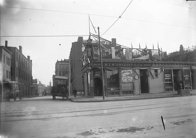
McGreevey's 3rd Base Saloon

From the Boston Public Library Flickr stream: McGreevey’s Third Base Saloon decorated with patriotic bunting during the 1903 World Series between the Boston Americans and Pittsburgh Pirates. The Saloon was decorated for the triumpant return of the team and of the Boston Royal Rooters from Pittsburgh, where Boston took a lead in the first World Series. The Saloon was located at 940 Columbus Avenue in the Roxbury Crossing neighborhood. From 5” x 7” glass-plate negative.

1800's Transportation in Roxbury by Jason Turgeon

It’s well-known that Roxbury was one of the first ever “streetcar suburbs,” but until I dove into the term I didn’t have a full sense of what that meant.  Roxbury did, in fact, flourish after the first streetcars but there is much more to the story.

Street car image from JP Historical Society

A 1930s streetcar at Guild Row on the same route once run by horse streetcars owned by the Highland Street Railway Company.

For the first couple of hundred years of Roxbury’s existence, the only way to get around for most inhabitants was to walk unless you were wealthy enough to own a horse.  In 1768, a census showed only 22 carriages in the entire city of Boston, and by 1798 there were only 145.  Roxbury being much smaller, there were probably many fewer carriages.  So most of the time, the poor walked and the rich rode horses.  And since Roxbury didn’t get its first paved street until 1824, when Roxbury Street was paved and brick sidewalks installed, going anywhere usually involved a lot of mud and very wet feet. 

Because of that, the community was small and dense.  Roxbury Street around Eliot Square (then known as meeting house hill because of the first church) was the major commercial district, with another large cluster of commercial buildings eventually growing up around the crossroads at Dudley Square.  A trip to downtown Boston would have involved an hour long walk or a slightly shorter ride on a horse, so you wouldn’t have been likely to venture into town very often.  If you had frequent business in Boston, you would probably move closer in.

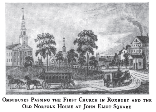
But by the mid-1820s, commerce between Boston and the surrounding cities and towns started to grow.  In 1826 or 1827, stage coach services connecting Boston with Roxbury, Charlestown, and East Cambridge appeared.  The Roxbury line terminated at the original Norfolk House, which was built in 1825.  These services were small, enclosed horse cars with benches facing forwards, like those pictured in most westerns.  This was not an optimal layout for passengers to get in and out frequently, they couldn’t carry many passengers, and they ran only hourly.  But they were a start.

By 1833, a man named Horace King, who had been employed as a waiter and general utility man at the Norfolk House for several years and had been saving his pennies, saw an opportunity to improve service.  He bought two vehicles, one of which was named the “Governor Brooks,” laid them out with the seats running along the sides facing each other and a door at each end of the car to make it easy to get in and out, and started the first omnibus service in Boston, from Norfolk House to the ferry at the foot of Hanover Street.  The round trip was 2 and 1/2 hours and the fare was 12 1/2 cents.

These first omnibuses were drawn by 4 horses with room for 24 passengers, 18 inside and 6 outside.  He experimented with various sizes of coach, from small 2-horse, 12-passenger affairs to massive 6-horse jobs that carried over 40 passengers, over the years.  There’s a marvelous children’s book called “Marco and Paul’s Voyages & Travels: Boston" that tells the story of two young men traveling from New York to Boston.  In it, young Marco sees his first Roxbury omnibus:

Paul goes on to explain that the larger omnibuses were something of an express route from Roxbury to downtown.  The smaller omnibuses were used on local routes, since the frequent stops and starts on a local route with a larger, heavier vehicle tired the horses out too quickly.

Within a few years King had control of almost all of the omnibus lines into the city and had over 250 horses and 150 men working for him.  He eventually bought and enlarged the Norfolk House and became incredibly successful, only to lose everything in the financial panic of 1856.  He moved home to Rutland and spent his last 40 years there in relative penury, eventually dying at the ripe old age of 96 in 1903.  To read more of his story, click on this link.

The next mode of transit to connect Roxbury to Boston was the steam railroad.  The Boston and Providence Railroad had started construction in 1832, and the spur to Dedham opened in 1834.  The Dedham spur followed the Stony Brook valley through Roxbury and had a stop at Roxbury Crossing.  But the train was less convenient and more expensive than the omnibus so it never really competed on the Roxbury Crossing stop, doing more to serve passengers coming in from farther away.

A view of the old Roxbury Crossing Station, with some of the first electric streetcars, just after the turn of the last century.

Between the omnibus service to various points in Roxbury and the train service, Roxbury’s population finally started growing.  In 1800, the town had a population of about 2700.  Thirty years later, after the coach service had started but before the omnibus and train were in operation, it was over 5200.  In the next 10 years, it grew to just over 9,000.  By 1850 it had doubled to over 18,000, with the vast majority of people riding omnibuses when they wanted to visit Boston or travel to Dorchester, Cambridge, West Roxbury, JP, or other suburbs.  

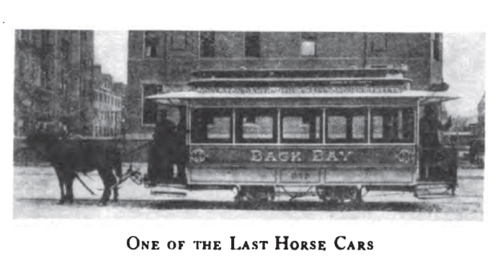
With the rapid growth in metro Boston, it was only a matter of time until a more efficient method of moving people from point to point became a necessity.  In 1856 that method finally arrived, in the form of the street railway system that had been pioneered in New York starting in 1852.  The first street railway system in Boston ran to Cambridge on March 26, 1856, followed in September by the Metropolitan railway company’s original line from Guild Row in Dudley Square to Scollay Square.

The street railway operators were private, for-profit operations that received charters from the state legislature to build their tracks on city streets.  The railway cars were drawn by horses and quickly settled into 4 major companies that each had a monopoly over its service territory, with the Metropolitan railway having the largest territory, serving East Boston, the Back Bay, Roxbury, Dorchester, Milton, JP, and Brookline.  

The first street railways weren’t necessarily popular with everyone.  Because they paved the area between the tracks, which was the only paved area in the street, people preferred to walk between the tracks.  Of course, this meant that they constantly had to move when the trains came, and for a brief time there was the complaint of “too many trains” from the pedestrian population. In Cambridge, the railway company’s opponents tore the tracks out of the street in the middle of the night on several occasions.  But before long the horse-drawn railroads gained acceptance, although the omnibus didn’t completely fade away for another 50 years.

The consolidation of the competition into 4 monopolistic lines eventually led to a decline in service, and by 1872 there were loud cries for more competition.  Among those demanding better service was our neighborhood’s own William Lloyd Garrison, who used his well-practiced sense of outrage.  In a letter from February of 1872 he bemoaned the situation to James Ritchie, a notable Roxbury resident and a man who was at the time one of the principal assessors for the city of Boston: “[The Metropolitan Railway Company] takes undue advantage of our Highland residents by inexcusably compelling them to be packed in those cars, frequently three times, and usually twice, beyond the number of seats provided; outraging all sense of propriety, at times bordering on indecency, in the enforced crowding together in a standing position of virtuous and refined ladies with coarse and vulgar men,—an exposure most trying not only to female delicacy, but highly favorable to the operations of pickpockets of both sexes.”

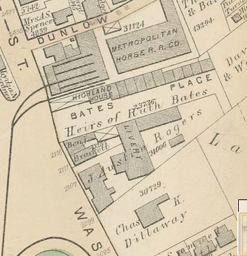
The 1873 map shows the Metropolitan horse barn at Eliot Square

Garrison and other residents were successful in getting more competition on the horse railways, and beginning in 1872 the Highland Railway company operated a service on the same lines that was widely regarded to be superior to the Metropolitan.  Of course, the arrangement meant that the Highland and other competing lines were using some of the tracks laid by the original railway companies, which were bitterly upset by this turn of events.  There were notable battles between the various companies, especially at the more popular spots where operators would jostle to become the first car in line, and if they lost out they would run the car as slowly as possible to try to become the first car at the next big stop.

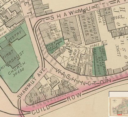
The same 1873 map shows the Highland Street Railway barn in Dudley behind Guild Row.  The Highland’s tracks ran up Shawmut, the Metropolitan’s up Washington.

In 1887, a businessman named Henry Whitney bought a huge tract of land in Brookline and commissioned Frederick Law Olmsted to lay out Beacon Street as a grand boulevard.  He laid railway tracks down this new street and formed his own railway company, the West End Street Railway Company, to shuttle people back and forth to his new subdivision.  The venture was a huge success, but the state of the other railway companies was so dismal that Whitney decided to take ownership of them so that his customers could get to their new homes more efficiently.  Amazingly, he was able to buy almost all of the old companies within the course of a year, and by the end of 1887 the West End Railway had 10,000 horses and all of the major street railways in Boston under its control.

The West End Railway horse barn in Eliot Square, at the same location as the Metropolitan barn shown above in the 1873 map.  The company had a larger barn on the site of the current MBTA bus yard at Bartlett Street and another one roughly on the site of today’s Jackson Square T stop.

Before long, the West End railway was working on plans to electrify the system and remove the need for thousands of horses to haul passengers.  Within 20 years, the era of horse-drawn transit in Boston was over.  

If you’re interested in finding out more about the rapid changes in rapid transit, there are plenty of good sources that detail Roxbury’s role:

From Coach and Omnibus to Electric Car

Bacon’s Dictionary of Boston: Street Railroads

The Street Railway System of Metropolitan Boston

Moving the Masses: Urban Public Transit in New York, Boston, and Philadelphia 1880-1912

William Lloyd Garrison’s letter to James Ritchie

Streetcar Suburbs: The Process of Growth in Boston 1870-1900

JPHS - Jamaica Plain Streetcars, a History